
The Olmos Dam Site (41BX1)
The Texas Historical Commission (THC) awards competitive grants from the Texas Preservation Trust Fund (TPTF) for planning, survey, restoration, preservation, and heritage education activities that support the preservation of archeological properties and associated collections from the State of Texas. The Center for Archaeological Research (CAR) at the University of Texas at San Antonio (UTSA) was awarded a TPTF grant in 2018 to rehabilitate the collections associated with the 1979-1980 excavations of the Olmos Dam site (41BX1). The rehabilitation included the repackaging of the collection into stable archival bags and boxes and the creation of a digital catalog. The grant provided CAR the means to protect the integrity of an important collection.
San Antonio is positioned on the edge of the Balcones Escarpment, where the Great Plains meet the Texas Coastal Plains. The city is located near a climatological boundary dividing a humid-subtropical climate to the east from the semi-arid climate to the west. These variations in geology, topography, and climate provide the area surrounding San Antonio with a varied resource base. San Antonio’s annual precipitation averages 76.2 cm (30 inches), but it is highly variable and unpredictable (Petersen 2001). The climate shifted throughout the Archaic period and was likely significantly different then the climate today (Lawrence 2010).
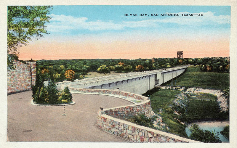
A series of devastating flood events have impacted San Antonio since its founding. A major flood in 1921 resulted in the deaths of 49 people (U.S. Army Corps of Engineers 1972). Olmos Dam was completed in 1926 to protect downtown San Antonio from floodwaters. Figure 1 depicts the dam circa 1940 (Eckhardt 2019). Site 41BX1 was originally documented in 1925 during construction of the Olmos Dam.
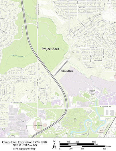
41BX1 was the first site recorded in Bexar County under the Smithsonian trinomial system. In this system, the number 41 stands for the state of Texas, the letters BX indicate Bexar County, and the number designates the archaeological site (TARL 2019). Today, over 2,000 sites have been recorded in Bexar County. Site 41BX1 dates to the Archaic Period (8800-1200 BP) with evidence of long-term occupation (Black 1989; Collins 2004; Hester 2004; Johnson and Goode 1994). The site is located north of downtown San Antonio near Olmos Creek and the headwaters of the San Antonio River (Figure 2). It spans approximately 1,011 meters north-south and 520 meters east-west (THC 2019).
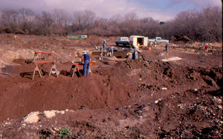
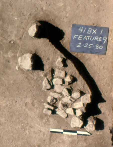
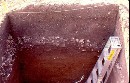
In 1925, avocational archaeologists documented a prehistoric bone bed associated with Plainview and Angostura points (Orchard and Campbell 1954). Much of the site was thought to have been destroyed. In the summer of 1979, archaeological excavations in advance of a scheduled dam renovation project by the San Antonio River Authority (SARA) identified three areas of prehistoric occupation (Assad 1979). Mitigation was initiated (Lukowski 1988, Figure 3). More than 14,000 pieces of debitage, multiple burned rock features, and temporally diagnostic artifacts were recovered indicating long-term human occupation at the site (Figures 4 and 5). These artifacts span the Archaic period, with a few dating to the Late Prehistoric (1200-350 BP). Burned rock features at the site were radiocarbon dated to the Late (4000-1200 BP) and Middle Archaic (6000-4000 BP; Black 1989; Collins 2004; Hester 2004; Johnson and Goode 1994; Lukowski 1988).
Lithic Artifacts
Lithic materials, including projectile points, lithic tools, debitage, and burned rock, are often the most numerous or only artifacts found at prehistoric sites. This is due to their important role in prehistoric material culture, as well as the durability of stone over time. Over 15,000 lithic artifacts were documented in the Olmos Dam collection (Munoz 2019).
Projectile Points
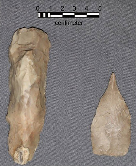
Seventy projectile points were recovered from the 1979-1980 excavations at 41BX1. Projectile points are important temporally diagnostic artifacts in prehistoric archaeology, as their forms change significantly over time. The assemblage of projectile points recovered from 41BX1 is consistent with long-term occupation of the site (Figure 6).
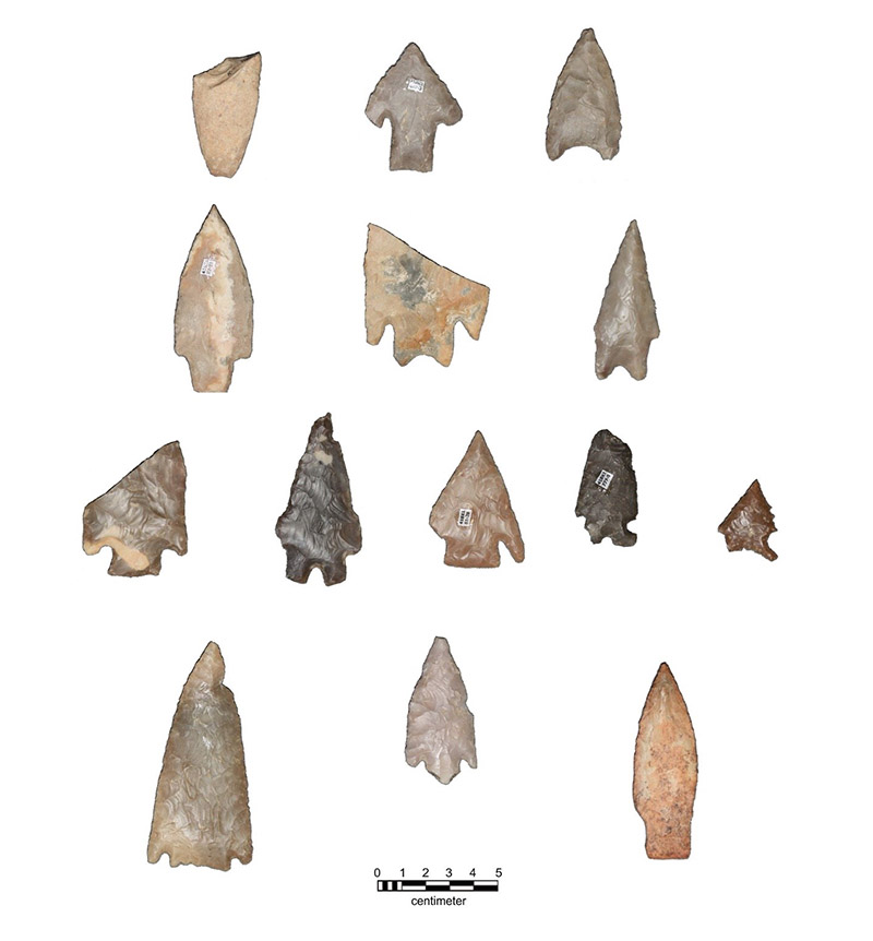
The top row in the figure includes an Angostura point at the left, a Bell point in the center, and a Kinney point at the far right. Angostura points in Central Texas date to the Late Paleoindian/Early Archaic Period (8450-7950 BP), Bell projectile points date to the Early/Middle Archaic (7950-5450), and Kinney points date to the Middle/Late Archaic period (4450-2950 BP). The second row from the top includes a Bulverde point at the left, and two Pedernales points in the center and right. Bulverde and Pedernales points date to the Middle/Late Archaic Period (4950-4450 BP and 3950-3150 BP). The third row from the top includes a Marshall point (2950 BP or earlier) at the far left, a Montell point (2950-1750 BP) in the center left, a Castroville point (2750-2350 BP) in the center, a Frio point (2150-1350 BP) in the center right, and an Ensor point (2150-1350 BP) at the far right. All five points on this row data to the Late Archaic Period. The fourth row shows a Castroville-like point (2750-2350 BP) at the left and two unidentified points. All of the projectile point dates are from Turner and Hester (1999).
Specialized Tools, Bifaces/Unifaces, and Edge-Modified Flakes
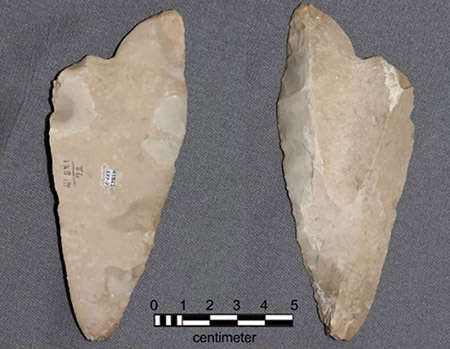
APEMapOther kinds of lithic tools found at prehistoric sites in Texas include edge-modified flakes, bifaces and unifaces, and specialized tools. Edge-modified flakes are less formal tools, consisting of flakes that have been worked along one or more of the edges, or sometimes they are simply flakes whose edges show evidence of use-wear. One-hundred and sixty-nine edge-modified flakes were recovered from 41BX1 (Figure 7). Bifaces and unifaces are lithic tools worked on both sides or only on one side. They may or may not show evidence that they were hafted, and their function is often unclear without examination of use-wear. This type of tool is very common at prehistoric Texas sites. One-hundred and forty bifaces/unifaces were recovered from the 41BX1 excavations (Figure 8).
Specialized tools, such as Guadalupe tools, are temporally diagnostic (Figure 9). Guadalupe tools date to the Early Archaic period (5450 BP or earlier; Turner and Hester 1999). The forms of lithic tools were adapted to meet the needs of the hunter-gatherers who used them, including the amount of effort put into manufacture, the tool’s reliability and functionality, and the effort required to maintain the tool (Bamforth and Bleed 1997; Bleed 1986; Bousman 1993).
Groundstone
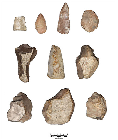
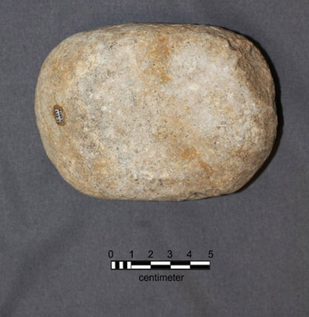
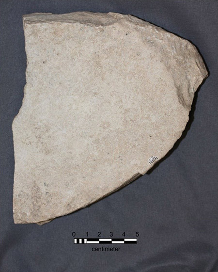
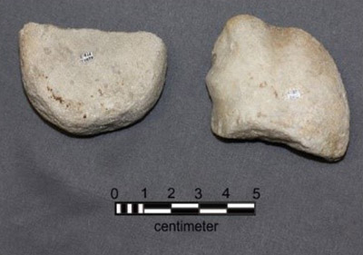
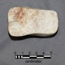
Eleven pieces of groundstone were recovered from 41BX1, including three manos/handstones, five metates/slabs, and two ground and pecked quartz cobbles. Groundstones in Central Texas likely served to process a variety of plant foods, as well as other materials such as pigments. The form of Central Texas groundstone is consistent with the region’s lack of agriculture. In contrast, evolving forms are seen in the Southwest, where farming of corn was prevalent (Gibson 2003). The metates from 41BX1 are made of limestone or sandstone (Figures 10 and 11). The function of the quartzite cobbles is unknown (Figures 12 and 13). Ethnographic reports from the Southwest note the use of “lightning stones,” quartz stones that are abraded smooth and emit luminescence when rubbed together (Barnett 1973).
Ceramics
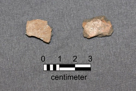
Two Native American ceramic fragments were recovered from 41BX1 (Figure 14). Both show evidence of burnishing. In Central Texas, Native American ceramics are associated with the late Prehistoric period (1200-350 BP).
Rehabilitation
The material from the 1979-1980 excavations of the Olmos Dam site is permanently curated at the CAR facility. The Texas Historical Commission Texas Preservation Trust Fund Grant awarded to CAR facilitated the rehabilitation of this important collection. The work included a reconciliation of the collection to fieldwork documentation and the creation of a digital catalogue of all the recovered artifacts. The collection was repackaged and labeled in accordance with current curation standards to prevent deterioration and maintain its integrity. All records associated with the project are preserved and digitized to prevent loss of data. The CAR rehabilitated 43 boxes of artifacts and 1.58 linear feet of records over the course of the rehabilitation (Munoz 2019). Work was completed by CAR staff, student interns, and community volunteers. This rehabilitation will help maintain the integrity of the collection, improve accessibility, and ensure that data from this site is available to researchers for decades to come.
References Cited
Assad, C.A. 1979 Archaeological Testing in the Devine Road Area North of Olmos Dam, San Antonio, Texas. Archaeological Survey Report, No. 53. The Center for Archaeological Research, The University of Texas at San Antonio
Bamforth, D.B., and P. Bleed 1997 Technology, Flake Stone Technology, and Risk. In Rediscovering Darwin: Evolutionary Theory in Archaeological Explanation, edited by C.M. Barton and G.A. Clark, pp. 109-140. Archaeological Papers of the American Anthropological Association, No 7. The American Anthropological Association, Arlington, Virginia.
Barnett, F. 1973 Dictionary of Prehistoric Indian Artifacts of the American Southwest. Northland Press, Flagstaff, Arizona.
Black, S.L. 1989 Central Texas Plateau Prairie. In From the Gulf Coast to the Rio Grande: Human Adaptation in Central, South and Lower Pecos Texas, edited by T.R. Hester, S.L. Black, D.G. Steele, B.W. Olive, A.A. Fox, K.J. Reinhard and L.C. Bement, pp. 17-38. Research Series No. 33. Arkansas Archeological Survey, Fayetteville.
Bleed, P. 1986 The Optimal Design of Hunting Weapons: Maintainability or Reliability. American Antiquity 51:737-747.
Bousman, C.B. 1993 Hunter-Gatherer Adaptations, Economic Risk and Tool Design. Lithic Technology 18(1/2):59-86.
Collins, M.B. 2004 Archeology in Central Texas. In The Prehistory of Texas, edited by T.K. Perttula, pp. 205-265. Texas A&M University Press, College Station.
Eckhardt, G. 2019 Olmos Dam. San Antonio Springs and Brackenridge Park. The Edwards Aquifer Website. Electronic document, http://www.edwardsaquifer.net/saspring.html, accessed August 15, 2019.
Gibson, C.T. 2003 Prehistoric Ground Stone Tools of Central Texas, Master's thesis, The University of Texas at San Antonio.
Hester, T.R. 2004 The Prehistory of South Texas. In The Prehistory of Texas, edited by T.K. Perttula, pp. 127-151. Texas A&M University Press, College Station.
Johnson, L., and G. Goode 1994 A New Try at Dating and Characterizing Holocene Climates, as well as Archaeological Periods, on the Eastern Edwards Plateau. Bulletin of the Texas Archeological Society 65:1-15.
Lawrence, K. 2010 A Recalibrated Chronological Framework for Texas Archaeology-Geoarchaeology, Master's thesis, Texas State University.
Lukowski, P.D. 1988 Archaeological Investigations at 41BX1, Bexar County, Texas. Archaeological Survey Report, No. 135. The Center for Archaeological Research, The University of Texas at San Antonio.
Munoz, C.M. 2019 Summary Report of the Rehabilitation of Collections and Records from the Olmos Dam Site (41BX1), Report on file, Center for Archaeological Research, the University of Texas at San Antonio.
Orchard, C.D., and T.N. Campbell 1954 Evidence of Early Man from the Vicinity of San Antonio, Texas. The Texas Journal of Science 4:454-465.
Petersen, J. F. 2001 San Antonio, an Environmental Crossroads on the Texas Spring Line. In On the Border: An Environmental History of San Antonio, edited by C. Miller, pp. 17-41. University of Pittsburgh Press, Pennsylvania.
Texas Archaeological Research Laboratory (TARL) 2019 Records and Archives. The University of Texas at Austin. Electronic document, https://liberalarts.utexas.edu/tarl/records/records-and-archives.php, accessed July 1, 2019.
Texas Historical Commission (THC) 2019 Texas Archaeological Site Atlas. Electronic document, https://atlas.thc.state.tx.us/, accessed June 12, 2019.
Turner, S.E., and T.R. Hester 1999 A Field Guide to Stone Artifacts of Texas Indians. Third ed. Gulf Publishing, Houston.
U.S. Army Corps of Engineers 1972 Flood Plain Information: Olmos Creek, San Antonio. Prepared for the City of San Antonio and the San Antonio River Authority.
