
Artifact Gallery
The artifact gallery contains images of lithics and artifacts recovered from Mission Concepcion. Visit the Mission Concepción gallery page to view those artifacts and photos from the excavation.
In the Beginning
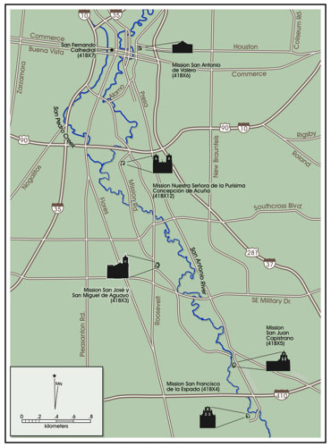
Mission Concepción was first established in East Texas in 1716 in present day Nacogdoches County. Between 1717 and 1718 a severe drought occurred in the area dramatically reducing harvests and causing food shortages. A smallpox epidemic added to the suffering (Habig 1968), and when Governor Don Martin de Alarcón visited the mission in 1718, he found it in dire condition. Although it was abandoned for a short period, the mission persisted until 1727 when it was closed and moved to the banks of the Colorado River. Two years later Mission Concepción was moved again and reestablished in San Antonio on the east side of the San Antonio River. It has been speculated (Ivey and Fox 1999:45) that the present site of Nuestra Señora de la Purísima Concepción Acuña was the first site of Mission San Francisco Xavier de Najera that was established in 1722 and abandoned in 1726 (Habig 1968).
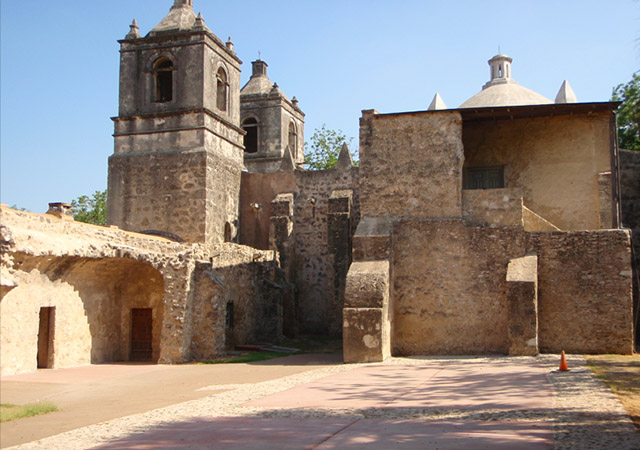
The Mission Compound
In general, the construction sequence followed by missionaries was to first build most facilities needed for day-to-day operations out of temporary materials until the first few years of occupation proved that the site was adequate (i.e., did not flood), that irrigation was possible, , and that the soils were productive. It is therefore expected that during the first few years, structures such as the church, the friary, and quarters for the native population (neophytes) would have been temporary jacales.
By 1756 when Fr. Ortiz returned to the mission, he noted that the new stone church was completed (Habig 1968) and described the exterior and interior of the church in detail. He found the friary in ruins but a new one was being built. The Indian quarters were jacales and other facilities included a weaving shop with three looms and a carpenter’s and blacksmith’s shop. He also described an irrigation ditch running through the plaza (Habig 1968).
 In 1762, Fr. Parras and Fr. Joseph Guadalupe Ramirez de Prado wrote that the friary was located next to the church and a large hall with two storerooms extended west of the friary, containing looms for manufacturing cloth. A granary, a blacksmith shop, and a carpentry shop also were present in the vicinity. The Indian quarters were arranged in two rows on two sides of the church and friary. An irrigated farm was located outside the compound walls.
In 1773, the College of Zacatecas, appointed Fray José Francisco Lopez as the new resident minister. In his inventory, he noted that the granary also functioned as part of the east wall of the compound behind the church.
Fr. Morfí described, in 1777, the mission with the Indian quarters arranged in two parallel rows on two sides of the friary and the square of the mission being completed by the granary on the east side. In 1789, Fr. Lopez mentions 23 Indian rooms and the granary located east of the church. The population of the mission steadily declined through the years and by 1794 only 38 individual resided on site. This same year, the mission was secularized. Remaining natives received land and Fray Josef Maria de Jesus Camarena, the last resident missionary of Mission Concepción, was relieved of his duties. The land was partitioned into 26 plots (Habig 1968). The ranch left the hands of the missionaries in 1777, well before the secularization of the mission.
The revolutionary forces of Bernardo Gutierrez de Lara chose the mission as their headquarters in 1813 (Gonzàlez 2009). Gutierrez was part of the Hidalgo Independence movement. Mission Concepción was a sub-mission of San José until 1824 when it was taken over by San Fernando Church (Cook 1980).
In 1806 Governor Antonio Cordero granted property adjacent to Mission Concepción and the granary to José Antonio Huizar (Almaráz 1982). Though Huizar never received the granary he was granted full title to the remainder of the property in 1815. The granary was granted to Manuel Yturi y Castillo in 1823 (Ivey and Fox 1999) and then deeded to Asa Mitchell by 1838 (BCCC Vol. A2:77). At that time, the granary consisted of three rooms, built of stone and connected in a row, and it adjoined the church at its southeast corner (BCCC Vol. A2:74). A survey of the property conducted in 1849 for Mitchell mentions the house that was used by Yturi (BCCC P1:619). It is thought that Ramon Musquiz owned some of the buildings, including the convento from 1824 until 1860. Bishop Odin began purchasing portions of the mission compounds that did not already belong to the church in 1841 (Ivey et. al. 1990). He purchased portions from Ramon Musquiz and transferred the building to the Brothers of Mary.
The Native Groups
When the mission was re-established on the banks of the San Antonio River, three principal groups present at the possession ceremony were the Paxalotes or Paxalaches, Borrados, and Manos de Perro (Habig 1968). Soon after its establishment, several other groups joined the missions, and by 1733, a total of 12 groups were present among the population residing at the mission. They included the Pajalat, Siguipiles, Tilpacipales, Patumaco, Pachalaque, Patalca, Tilija, and Xarame. According to marriage records, members of another 25 native groups joined the missions between 1734 and 1775.
Campbell and Campbell (1996:22-44) identify 33 native groups based on early marriage registers from Mission Concepción. The majority of native groups were from South Texas and the Texas Gulf Coast (Campbell and Campbell 1996: Table 2), with a smaller number from Northern Mexico, including Tamaulipas and Nuevo Leόn.
Population Trends
As in the case of the other missions in the upper San Antonio River basin, constant fluctuations in the population of Mission Concepción was influenced, in part, by the frequency and timing of epidemics and availability of resources in and away from the missions.
One of the earliest population counts for Mission Concepción comes from early in 1739 and indicates that there were 250 native inhabitants in the mission prior to the smallpox-measles epidemic strike later that same year. By the first part of the following year, the mission population was reduced in half (Habig 1968:126). In 1745, a Queretaran census report indicated that there were 207 individuals in residence.
In 1772, the mission was transferred to the College of the Zacatecas. Fr. José Saenz de Gumiel served as the last Queretaran president, and his inventory of the mission listed a population of 171 Natives, five Pajalat, 18 Tacame, 14 Sanipao, 48 Manos de Perro, and 18 Toareque (Gonzàlez 2009). By 1789, there were only 71 native members living in the mission, and in when the mission was partially secularized in 1794, the number of neophytes had dropped to 38 (Habig 1968). By 1809, the number of Spanish residents outnumbered the native individuals residing at the mission (Habig 1968:143). The mission was fully secularized in 1824.
History of Archaeological Projects
The first investigations of the mission occurred during the early 1930s, when Harvey P. Smith directed excavations under the Works Progress Administration (see bibliography of reports of investigations). These excavations centered on the mission structures and the identification and mapping of buried foundations south of the convento and sacristy. While resulting in a map showing the locations of extant structures and buried foundations, no notes associated with the investigations have been located to date.
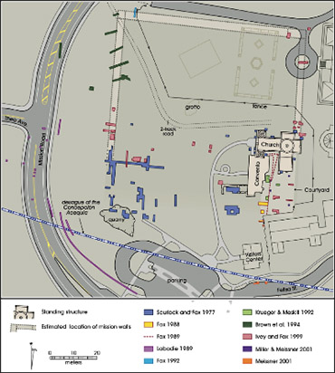
The first professional archaeological investigations at the site took place in 1971-72 and were carried out by staff of the Texas Historical Commission (Scurlock and Powers 1975; Scurlock and Fox 1977). The most recent investigations occurred in 2006 and were conducted by the staff of the Center for Archaeological Research.
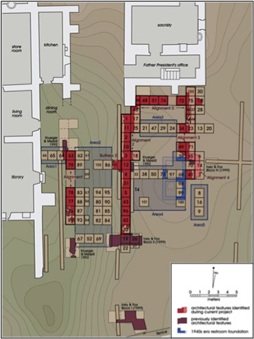
Between 1971 and 2009, 11 formal and systematic archaeological investigations were carried out within the bounds of the mission and immediately outside of its walls. With the exception of the Texas Historical Commission project of the early seventies, all other projects were carried out by the staff of the Center for Archaeological Research. The majority of the efforts were prompted by improvements to the mission grounds (Brown et al., 1994; Fox 1988; Miller and Meissner 2001), road realignments (Ivey and Fox 1999), and drainage improvements associated with rainfall runoff (Fox 1988). A smaller number of projects served as archaeological field schools for students of The University of Texas at San Antonio (Figueroa and Tomka 2009-shown on opposite page). These investigations focused on the courtyard area and uncovered the remnants of the convento and granary. In combination, the salvage and systematic testing projects have resulted in a comprehensive sampling of all portions of the compound, including the courtyard, the granary, areas outside of the walls, and the nearby acequia.
Accessions and Content of Collections
The CAR’s curation facility holds materials from 11 accessions associated with investigations at Mission Concepción. The accessions include materials recovered during surface collections and various levels of testing and data recovery. The earliest of the accessions consists of materials obtained in 1971, while the latest represents collections associated with multi-year (2002-2005) investigations in the courtyard of the mission in preparation for grade improvements that were needed to prevent water damage to frescoes lining the wall of the friary (Figueroa and Tomka 2009).
All but two of the archaeological investigations at the mission were carried out by the Center. The remaining two projects were conducted by the Office of the State Archaeologist under the sponsorship of the Texas Historical Commission. All of the collections from projects conducted at the site are curated at CAR. All eleven accessions contain artifacts and the associated project-related documentation including field notes, photographs, and analysis data sheets.
The total number of artifacts exceeds 110,000 specimens. In its electronic curation database, the CAR has detailed artifact-class level inventories for 100 percent (n=110,479) of these collections. Native-made materials consist of chipped and ground stone artifacts and undecorated ceramics. Gun flints and arrow points made of copper reflect the influence of recycled materials on native technologies. The other artifacts represent the continuation of prehistoric technological traditions and their adaptation to the manufacture of artifacts used by Spanish soldiers (i.e., gun flints). Spanish-made items consist primarily of tin glazed and lead glazed ceramics, while post-secularization historic artifacts include European ceramics and a variety of glass and metal objects A large portion of the animal bones recovered from the site date to the Colonial Period although saw-cut bone dating to the mid-nineteenth century also is common.
The projects carried out at the mission document the history of reconstruction and restoration efforts, facilities improvements, and systematic archaeological investigations. As such, they reflect the history of conservation efforts within the city, first through the San Antonio Conservation Society, and later by the San Antonio Missions National Historical Park.
These collections of artifacts can be grouped into the following broad categories: chipped lithics, ground stone, ceramics, and metal artifacts. Images of selected artifact classes are shown in the artifact gallery. The selection of images will be updated from time to time as additional artifacts are photographed.
