
Archaeologists, volunteers, and interns at CAR understand that learning is a life-long project and often includes the pleasure of traveling. Not surprisingly, many of their travels include visits to other archaeological, historical, or cultural sites which are shared on this page.
Olduvai Gorge, Colonel (Ret.) Thomas Ty Smith, Summer 2024
CAR volunteer Colonel (Ret.) Thomas Ty Smith and his spouse Holly were recently traveling across the great Rift Valley in Tanzania enroute to the Serengeti when they had an opportunity to make a side trip to Olduvai Gorge.
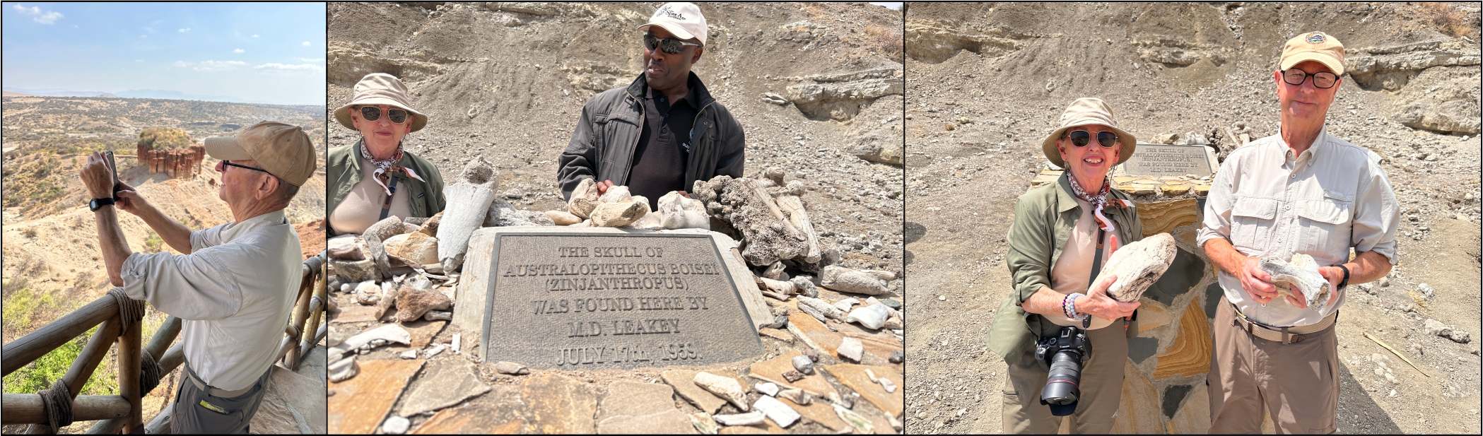
The first photo on the left is Ty overlooking the gorge. Mary D. Leakey's great discovery of Australopithecus boisie in July 1959 was just beyond and down from the red cliffs to the left. Ty and Holly were fortunate to be able to travel down into the gorge and go to the actual exact site of the discovery, here marked by a brass plaque and memorial (center photo). The photo on the right is of Ty and Holly in front of the memorial holding one million-year-old elephant bones.
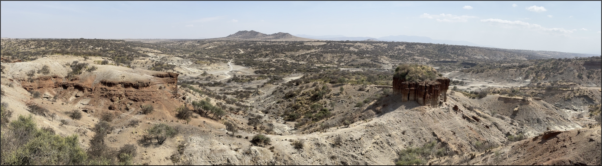
The photo above shows a beautiful panorama of the Olduvai Gorge.
Adventure is Out There!, Mikaela Razo, Peru, Summer 2022
Over July and August of 2022, I had the great fortune of joining a small group of researchers and UTSA Anthropology Department Professor Dr. Rebecca Bria on her project, Proyecto de Investigación Arqueológico Regional Ancash (PIARA), in the Andean highland community of Hualcayán. This season mostly consisted of ceramic reconstruction and artifact analysis, community outreach and engagement, and potential projects. It is a journey to get to Hualcayán, located in the northern Ancash region – a full day’s travel via plane, a 12-hour bus ride, followed by an hour and a half taxi ride –the warm kitchen and the smiling face of local and good friend, Shayla, made it all worth it.
Peru is home to a diverse number of ecosystems (and archaeological sites) due to its range in elevation, going as low as sea-level and as high as 22,200 feet. Our 12-hour bus ride from Lima to Caraz offered the opportunity to view some of these ecosystems. Our journey started along the fog-filled coast desert and, as we drove further north between the Cordillera Negra and Blanca, the scenery changed to seemingly long plains and winding rivers. The snow-capped mountain range in Peru, the Cordillera Blanca, offers spectacular views of glaciers (left image below) during the day and the occasional lightening-filled storms that light up the sky at night. The short taxi-ride up from Caraz to Hualcayán displayed Ancash’s vertical agriculture within an elevation range of 3,000 feet – a patchwork of different colors within a sprawling valley (middle image below). A small hill located in Hualcayán offered a wonderful reading spot that overlooked much of the community, the agricultural fields, and the Cordillera Negra (right image below).

After a month in Hualcayán, I returned to Lima and made my way to Sandoval Lake, located in the Tambopata Reserve, Madre de Dios Region. This portion of my trip yielded an entirely different experience. Located within the Amazon not far from Cuzco, Sandoval Lake offers its visitors a non-invasive glimpse into local wildlife around the clock. We were able to quietly enjoy the sun rising and setting ( left image below) and both watch and listen as diurnal and nocturnal species took their turns awakening. A few mornings, we arose before the sun did to make a trek out to the resting sites of local macaw groups ( middle image below). We were also able to watch as varying monkey species traverse the tall trees, including Capuchin, Squirrel, and Howler monkeys (right image below).

The final portion of this trip landed me back in Cuzco before we made our way through the Sacred Valley towards Machu Picchu. A UNESCO World Heritage Site since 1983 and one of the Seven Wonders of the World, Machu Picchu offers its visitors a glimpse of South American history (see photos below). One of my travel companions, Llamita (little llama), acted as a good photo subject as we wandered through the rooms and pathways of the site. Everywhere you look, there is always a view of something unforgettable whether it be the site itself and its complex constructions, a valley or river, the rising or setting sun, or the resilience of human nature displayed. No picture will ever be able to fully encapsulate the wonder and magic Machu Picchu can bring about in its visitors. Despite the heavy looting that Peru has been subjected to since the arrival of the Spanish in 1526, the archaeological sites found within testify to the innovation, ingenuity, and intelligence of Andean peoples prior to its contact with the West and subsequent colonization.

Are all Mounds Created Equal?, Peggy Wall, July 2022
I had the most extraordinary opportunity this summer to visit 18 mound sites in the southeastern United States and in the Midwest. The mound builders, of course, were not all the same in language or culture, though there are similarities between many. The mounds were also not all built at the same time, but most were built near rivers or streams. Many were used as burial mounds. Many platform mounds were built upon for ceremonial purposes (temples) or they were used as homes for the elite. Effigy mounds are thought to have played a ceremonial role in the lives of their makers. Some mounds were built quickly, others were built over hundreds of years.
The most striking examples were Poverty Point World Heritage Site in Louisiana, Cahokia State Historic Park in Illinois, and Moundville Archaeological Park in Alabama. If you are only able to visit three mound sites in your life, I would recommend these three. In the photos below, on the left, is Poverty Point where they have inserted white markers where postholes were found in the 43-acre plaza for a circle that is 213 feet in diameter. Poverty Point is the oldest mound site in the United States open to the public, built beginning about 3700 BP. It is also unusual as it was built by ancient hunter-gatherer groups—there was no agriculture at the site. No other earthworks surpassed Poverty Point for over 2000 years! Excavations have also suggested that the largest mound at the site, Mound A, was built quickly--within a few months—a movement of 390,000 tons of earth! While some of the mounds, such as the semi-circles around the huge plaza that Poverty Point is known for and where houses were constructed, are difficult to see (the stewards leave grass growing so the mounds can be seen better) --it was only by driving and walking around that you realize the size of the site. This was no small endeavor!
The middle photo below shows an approach to Monk’s Mound, the largest mound in North America (north of Mexico) at Cahokia Mounds State Historic Park at Collinsville, Illinois. The museum/interpretive center is closed for renovation, but you still can walk around the site. They have also begun an augmented reality project that will superimposed structures on the landscape via your phone or tablet (for those with better phones than me!). Cahokia was a large city from around 1000 to 700 BP.
On the right, below, is a picture of mounds at Moundville Archaeological Park in Alabama taken from the top of Mound B. There are 28 mounds here in over 300 acres that was in its glory 1000 to 800 BP. It is visually stunning as you drive around the park.

However, this does not mean that other mound sites were any less impressive. Parkin Archeological State Park in Arkansas is the only mound site in the United States whose name is known. Evidence (brass bell, glass “chevron bead”, lead shot, and descriptions of the village in expedition accounts) suggests that Hernando de Soto stopped at this Mississippian site in present-day Arkansas in 1541, during his exploration of the southeast. The name of the village and the chief were Casqui.
Effigy Mounds National Monument contains at least 200 earthen mounds in various shapes, from bears to birds. Most are difficult to see as they do not rise to a great height. These were placed on the top of bluffs bordering the Upper Mississippi River near Harpers Ferry, Iowa from 1400 -750 BP. The Great Bear Mound can be seen below in the left photo.
Hopewell culture flourished from 2100-1500 BP in the northeastern and midwestern United States, and produced many earthworks with geometric designs: rectangles, squares, large and small circles. How cool is that? A portion of the Great Circle Mounds in Newark, Ohio can be seen in the middle photo below—the ditch which would have been filled with water is inside the great circle, which is to the immediate right of the ditch. This is considered to be ceremonial, not defensive, since a defensive moat would be place outside of the great circle.
In Texas, there is the Caddo Mounds State Historic Site (right photo below) near Alto. About 1200 BP, the Hasinai or their ancestors, built this mound site in east Texas. A recent tornado tore down the visitor center and Caddoan(?) house that had been there. These are now being replaced and rebuilt.

Aztalan State Park in Wisconsin was the northernmost mound site I visited, a settlement said to be related to Cahokia over 300 miles to the south, inhabited from 1000 to 700 BP. It had a stockade around the town that has been partially reconstructed (see left photo below).
Grave Creek Mound is the largest conical mound in the United States, located in Moundsville, West Virginia. It was built by the Adena people as a burial mound about 2200 BP and contained many burials (see middle photo below). The museum near the mound is one of the best I found on the trip.
Ocmulgee National Monument near Macon, Georgia was the site of the largest archaeological dig in United States history, during the 1930s. An amazing 2.5 million artifacts were found during the excavation. Etowah Indian Mounds State Historic Park (https://gastateparks.org/EtowahIndianMounds) in Cartersville, Georgia has six earthen mounds. Both had excellent museums. The photo on the right below shows statues found during excavation at Etowah—there is paint on them!
My last visit to a mound site made me sad…Spiro Mounds has been heavily looted. Craig Mound was excavated commercially in the 1930s and the burial chamber was later dynamited by them. Artifacts were sold around the world and most remain lost today or in other museums. It is a reminder of all that has been lost.

Cynthia Munoz and Raymond Mauldin, Lisbon, Portugal, June 2022
Lisbon, Portugal is home to beautiful churches, convents, monasteries, and castles reflecting its overwhelming history. Prehistoric and historic archaeological sites dating to the Neolithic, Roman, Moorish, and Early Christian Periods can be found in and around the city. We were struck by the majesty of the Church of Sao Dominigos (left photo). Established in 1241, Sao Domingo was home of the inquisition. It was damaged by the 1531 and 1755 Lisbon earthquakes. Picturesque Moorish castles are located on hills throughout Portugal (middle photo). The Christians conquered them in 1147. We also enjoyed Rossio Square (right photo). It was the scene of markets, bullfights, beheadings, and auto-da-fe (inquisition). The tile work creates a great optical illusion.

Susan Lisk, Volunteer, Cahokia Mounds State Historic Site, IL, May 2022
If you’re planning to visit Cahokia, do the research - read the books and articles, and watch the videos (maybe even one that suggests alien visitations), because when you get there, and try to wrap your mind around what was once there, you’re still going to say “what tha!?” Even with the loss of so much of the city and associated areas to development, farming and highway construction, there is enough of the Grand Plaza, Woodhenge and mounds to give an idea of the original size - and it’s BIG! It’s also very accessible, and has information boards and well-marked trails, as well as online interactive maps and other resources. The Interpretive Center is closed for renovations - check their website for updates. The photo shows the view from the top of Monks Mound looking south over the Grand Plaza. Buildings and the arch in St Louis are visible to the west from the top of Monks Mound.

